Tongariro Crossing, Tongariro Northern Circuit, NZ Great Walks 🥾 ⛺️
Day Two of my solo backpacking tramp of the Tongariro Northern Circuit track saw me hiking from the Mangatepopo Hut over the Tongariro Alpine Crossing to the Oturere Hut. There is more space to camp at the Oturere Hut than Mangatepopo and initially i chose a spot overlooking the Kaimanawa Range however as the wind started to pick up, I relocated my tent to a lower spot.
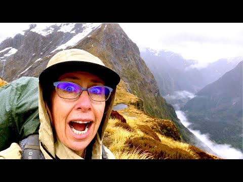
Highlights of the day included the Tongariro Crossing, known as one of New Zealand’s best one day walks, the Emerald Lakes, the South Crater and the Red Crater and the long long walk down the Oturere Valley which was unbelievably dry. Talk about a desert! The weather was brilliant and the views to Mount Ruapehu, Tongariro, Ngauruahoe and even all the way to Taranaki are extraordinarily beautiful.
Lowlights was not refilling my water bladder before setting out, I finished all my water before reaching the hut and in that heat, it wasn’t good. There’s no access to water anywhere on this route except at the huts and the Oturere Hut water tank was almost completely out and the next day, did run out of water.
The section that included the Crossing was relatively busy although nowhere near as busy as a couple of years previous when you had to queue to get up the Devil’s staircase. Fantastic to see so many people out there enjoying it. Once I’d left the Crossing section, the crowds immediately dropped and I only saw a couple of other hikers between leaving the Emerald Lakes and the Oturere Hut.
Lord of the Rings fans will recognise Mount Doom / Mount Ngauruahoe which was the volcano in Mordor where the One Ring was forged, and the only place it could be destroyed.
ℹ️Stats
📅 Date: 8th January 2022
☀️Weather: 28 degrees Celsius on the Crossing
⏮ From: Mangatepopo Hut - Devils Staircase - Tongariro Crossing - Emerald Lakes - Dragons Tail - Oturere Valley
⏭ To: Oturere Hut
⛺️ Accommodation: $ Camping
👏 Difficulty: Intermediate Great Walk / Easier Tramping Track
🥾Distance: 11.46km
🏔 Elevation Gain: 511 metres
🏔 Max Elevation: 1,875 MASL
🏃🏼♀️Average Speed:
🏃🏼♀️ Moving Time: 3:35:31 hours
Elapsed Time 7:15:04
🥑Calories burned: 755
🥾 Boots: Iowa Lavenaii GTX Lowa Boots